Habitatway
Landscape Level Wildlife Conservation Methods and Resources
I. The World in General
The constant and unrelenting impacts of 8 billion plus humans on the earth is taking a dramatic toll on our underlying natural systems. The layered biodiversity and the capacity of natural systems to perform the many ecosystem sustaining functions, upon which we all depend are fracturing. We must boldly act if we hope to be able to depend on, and use, the functional natural systems. Habitatway.net is a webpage to highlight tools and hopeful stories that are in play (or could be) which help to ameliorate the impacts 8 billion + people on our dwindling natural systems and biodiversity.
I look forward to finding new tools and descriptions and stories from other areas and people on how our earth and the biodiversity naturally evolved and supported is, or may be sustained, restored and protected. More needs to be done by many, and soon.
Below is one such effort that is grandiose in concept, but may be the common thread that helps to spawn many important conservation efforts worldwide.
The Half Earth Project: Half-Earth is a call to protect half the land and sea in order to manage sufficient habitat to safeguard the bulk of biodiversity. Advances in technology now allow us to comprehensively map the geospatial location and distribution of the species of our planet at high enough resolution to drive decision-making about where we have the best opportunity to protect the most species and sustain life-giving ecosystem functions and services. The actions/plans/efforts to protect the most species and sustain life-giving ecosystem functions and services on our home planet earth, is the work of the Half-Earth Project.
Whether it’s half of the earth, more, or less, is not the main point. The point is with the extensive transformation of our planet to suit us – our growing population, expanding energy, food, infrastructure and technology and the purely physical space demands – it is in our human own interest to conserve and protect existing natural ecosystems and the varied lifeforms they support. Failure to do so will shrink our possibilities to continue to survive.
The Half-Earth Project proposed and discussed by the E.O Wilson Foundation presents an achievable plan to save our imperiled biosphere: devote half the surface of the Earth to nature. In order to stave off the mass extinction of species, including our own, we must move swiftly to preserve the biodiversity of our planet, says Edward O. Wilson in his most impassioned book to date. Half-Earth argues that the situation facing us is too large to be solved piecemeal and proposes a solution commensurate with the magnitude of the problem: dedicate fully half the surface of the Earth to nature. The Half-Earth Project web site is a good point of departure for those interested in becoming a part of this large world-wide conservation project.
I live in Florida so I will begin with the work we have accomplished here.
II. Florida
Background
Florida is a World Leader in natural and working lands conservation, but significant work remains within Florida, and to link outward to our neighboring states!
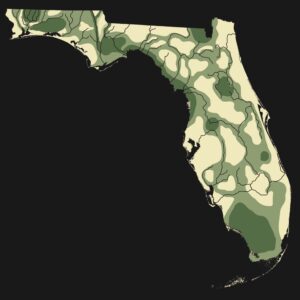
A wildlife, habitat and ecosystems conservation approach (and by the way, also a climate change mitigation strategy, and micro climate development tool where) of growing importance was proposed by the late Harvard University scientist Dr. E.O. Wilson. He described the approach as Half Earth where we strive to sustain or create “a chain of uninterrupted corridors forming, with twists and turns, some of them opening to become wide enough to accommodate national biodiversity parks, a new kind of park that won’t let species vanish.” Half-Earth is a call to protect half the land and sea in order to manage sufficient habitat to reverse the species extinction crisis and ensure the long-term health of our planet.
In this regard, Florida has been a leader in developing a landscapes of connected conservation corridors and set asides sensitive and vulnerable natural areas and rural lands through a sustained history of land conservation efforts such as Save Our Rivers, Preservation 2000 and Florida Forever. Florida has experienced tremendous and continuing population growth over the last 50 years and the concurrent human development and re-shaping of the land has damaged many of our sensitive and vulnerable natural resources, native species and historic rural ranching landscapes. From our land conservation programs overtime we have learned important lessons regarding landscape level conservation approaches and networks.

First lesson: There are important core parcels or areas that need to be sustained in “bulk” to allow continuance of their most natural conditions as is possible. These are areas that due to inherent natural sensitivities; development limitations or important ecosystem support functions, deserve special recognition and the highest level of protection (e.g., acquisition and management for conservation purposes). Importantly, these core areas need to be sustained and viability supported via multiple cross land/water links extending outward to other areas.
Second lesson: There are significant lands/waters providing important natural resource conservation functions that are privately owned and carefully managed which lend support to the core areas. These private lands often serve useful wildlife conservation functions, important economic functions such as forestry, managed grazing and a host of ecosystem maintenance services (e.g., collect, hold and filter surface and ground water.) Within the greater conservation framework, it is beneficial to develop and offer approaches such as conservation easements, owner conservation management plans or development of other private uses and economies that support an area’s long-term conservation over the landscape’s development for suburban, urban or infrastructure use (e.g., well managed ranch lands, regional forestry, etc.)
Third lesson: Some lands/waters making up a conservation network will be added over time to strengthen or buffer resource protection aims, while other lands/waters may be “lost” and developed. Though, as noted above, certain core lands/waters need to be carefully sustained and most vigorously protected. Important conservation network lands/waters may be added and grow the network (e.g., through mitigation and restoration actions) and other lands may be “lost” or removed from the conservation network due to development or severe landscape alterations.
Fourth lesson: At times – in some locations, multi-use options can coexist on conserved landscapes such as trails, bike paths, canoeing, camping, hunting, or other low intensity uses which help build economic and cultural value, constituencies and community buy-in and support for natural conservation areas and their long-term existence (these users of the conserved areas willingly speak-up for conservation.)
Finally, and most importantly, for conservation efforts to continue and for the State to serve as a world-class model, there is the need for long-term funding to help support (e.g., funds for fee simple acquisitions, less-than-fee acquisitions where some development rights are acquired or, funding support programs to assisting private well-managed lands to remain profitable as economies and conditions change.) Funding for the Florida Forever Program as reported by the State’s program operator, the Department of Environmental Protection (FDEP):
“In 1998, Florida voters amended the state constitution by ratifying a constitutional amendment that re- authorized bonds for land acquisition. The 1999 legislature responded with the ten-year $3 billion Florida Forever program to acquire and manage land for conservation. This was extended another 10 years in 2008 for a total of $6 billion.
In 2014 Florida voters amended the state constitution again, ratifying a constitutional amendment that dedicated 33 percent of documentary stamp taxes to:
“finance or refinance acquisition and improvement of land, water areas, and related property interests, including conservation easements, in order to conserve wetlands, forests, and fish
and wildlife habitat; protect water resources and drinking water sources, protect the water quality and quantity of rivers, lakes, streams, springsheds, and lands providing recharge for
groundwater and aquifer systems; conservation of lands in the Everglades Agricultural Area and the Everglades Protection Area, as defined in Article II, Section 7(b); protect beaches and
shorelines; provide outdoor recreation lands, including recreational trails, parks, and urban open space; protect rural landscapes, working farms and ranches, and historic or geologic sites; and provide for the management and restoration of natural systems, and the enhancement of public access or recreational enjoyment of conservation lands.”
In Florida, the basis for funds has come from the collection of a documentary stamp tax on all land sales transactions.
Thus, every time someone, or an entity, buys land or transfers title on the land a fee is collected and places into a land and water conservation fund. In Florida, where lands are constantly bought and sold, this has allowed large sums to be accumulated for landscape level conservation efforts.
FDEP, the state land management agency, manages the Florida Forever Program but the funds are distributed to a variety of other conservation related agencies agencies and to the state’s five water management districts to fund and support specific land buying and management efforts.
In addition to dedicated State funding, funds from many other sources (e.g., local, private, federal, international) may sought and bundled to make projects happen and maximize project benefits.
Florida’s network of conservation lands and importantly, the funding mechanism, present a template for landscape conservation actions elsewhere in the world. We need to brag about it and promote its extension northward to our neighboring states of Georgia and Alabama and beyond. Florida’s network has multiple large nodes of conservation lands (i.e., the “bones” such as Everglades National Park, multiple State and National Forests, local large parks, aquatic preserves) but still needs improved corridor linkages in places between nodes to foster movement of wildlife, dispersal of plant communities and water collection, storage and filtering to sustain the important natural ecosystem functions overtime.
Important Conservation Landscape Components and Remaining Actions:
-
- Sustaining a network of public and private lands where core portions are essentially “sacrosanct”– that is, of such high an enduring resource value and/or so highly vulnerable to disturbance or loss that they are acquired outright. These areas serve as anchors or major nodes for the long-term conservation of Florida ecosystems and landscapes.
- Continuing to identify and provide additions to important conservation lands/waters to build and grow areas of biodiversity value and strengthen their design to foster longevity and sustainability.
- Support and accommodate working landscapes of private, nonprofit and public land/water corridors that link and help to buffer and extend “natural” areas of biodiversity importance (e.g., family ranch lands and private silviculture areas, water conservation, wellfield catchment, city and county parks and other natural recreation areas.) These working landscape areas may be viewed as “more malleable” than essential core areas. They may have valued private uses and management arrangements, but they still provide and sustain important biodiversity conservation needs, often abutting and extending the protections to core conservation areas.
These areas may find reasonable resource conservation use and measures through an owner’s land ethic and careful natural resource husbandry or, even via subsidy by prescribed limited payment(s) or economic benefit(s) to private landowners. Payment for management of prescribed ecosystem services most clearly foster defined public good and sustained natural ecosystem services and native biodiversity support. These “between core areas”, if carefully managed for conservation and native Florida biodiversity functions, serve as important parts of a connected conservation corridor network. They may employ fully private lands or less-than-fee public acquisition and/or management approaches – such as delimiting conservation easements, owner land management agreements, payments for maintenance and management of defined ecosystem services. As noted, these lands may often adjoin and protect publicly acquired conservation lands and function to link and bridge between major public conservation areas.
Florida has made notable progress in the development of a world-class conservation lands network. The network though, is still a work in-progress. It remains incomplete, both internally within the state and externally – linking outward to our neighboring states of Alabama and Georgia. For example, in time the conservation lands network would benefit by improved linkages to Georgia such as up through the Pinhook and Okeefenokee Swamps, to Alabama up through the Conecuh National Forest or, following along other rivers or natural system linkages.
Numerous conservation linkages and gaps in Florida’s conservation network have been identified for consideration, for example (to name a few):
-
- Apalachicola River Corridor, in particular, areas of bottomland hardwood forest in the floodplain and more upland areas of unique Florida bluffs and ravines adjacent to discontinuous parcels of Torreya State Park in Gadsden and Liberty counties.
- Blackwater River and Blackwater State Forest linkages to the Conecuh National Forest in Alabama.
- Central Florida’s Green Swamp lands that protect and maintain the remaining groundwater aquifer’s potentiometric levels (Central Florida’s Water Tank) and better link to the fragmented Withlacoochee State Forest lands.
- Okaloacoochee Slough linkages between Big Cypress, Okaloacoochee Slough State Forest and Corkscrew Swamp in Collier; and,
- Many springshed protection parcels necessary to sustain Florida’s springs.
- Lake Okeechobee basin and south through the EEA and then to other original greater Everglades ecosystem lands.
Florida’s conservation efforts deserve to be carefully described, featured, managed and expanded upon as the human population continues to grow. We need to preach about our successes and demonstrate our Half Earth conservation approaches to others around the world and continue to reach out to learn others regarding how we might improve and enhance our efforts.
Long-term efforts and Tools In Florida
A. The Florida Wildlife Corridor Foundation
There have been many lives, minds and hands that have helped in the development of what has become knw as the Florida Wildlife Corridor. A good quick history can be found in, The History of Florida Wildlife Corridor by Hoctor, T., R. Noss, R. Hilsenbeck, J. Guthrie, and C. Ward. Science and Planning Efforts. (2015). Web. 11 November 2015.
http://floridawildlifecorridor.org/about/history/.
The concept of a statewide ecological corridor is not new to Florida. The Florida Wildlife Corridor relies on and continues the decades of work by numerous scientists and conservation organizations that determined the need for landscape-scale conservation approaches, and specifically corridors, as a way to address habitat loss and fragmentation across Florida. These decades long efforts brought into play the right combination of people, need, and opportunity, resulting in arguably the most ambitious landscape conservation plan of any U.S. state.
In the 1960s and 1970s E.O. Wilson and Robert MacArthur had a strong influence on the development of modern conservation science, including the new discipline of Conservation Biology in the 1980s. In Florida, leading researchers, Reed Noss and Larry Harris advocated a comprehensive regional landscape approach that recognized the need for working at large scales and integrating both protected and more intensive land uses to maximize conservation efforts. Harris and Noss authored a series of articles and book chapters in the mid-1980s discussing the importance of ecological connectivity, wildlife corridors, and the protection of functionally connected networks of conservation lands. This included detailing the strategic value of protecting specific tracts of land in Florida that would result in larger, connected conservation networks. In 1985 Noss proposed the first statewide ecological network.
The Wildlife Corridor Foundation is a group that has been established to foster and present a unifying voice that provides a window into wild Florida. The Foundation seeks landscape-scale conservation through high quality, impactful, and authentic storytelling. The Foundation members and partners are many, they are paddlers, hikers, biologists, birders, ranchers, fishermen, snorkelers. They seek to weave exploration and science with the stories of the wildlife, wildlands and those who steward it into our State’s most compelling conservation story – to save the Corridor.


